Zoom into Google Maps and it turns to mush.
Zoom into a drone map and you can count the fence posts. Satellite imagery holds a couple of feet per pixel. A drone map holds about an inch.
See the gallery ↓
Drone mapping guide for realtors
Selling acreage is different from selling a house. The land is the product, and buyers want to see boundaries, access, and features before they drive out. Here is everything agents ask us about drone mapping, aerial photos, and property lines, answered straight.
Skip to the proof
Zoom into a drone map and you can count the fence posts. Satellite imagery holds a couple of feet per pixel. A drone map holds about an inch.
See the gallery ↓Stitched aerials warp at every seam and tip the trees sideways. See the same property done both ways, and why only one of them is measurable.
Spot the difference ↓That's what a recent commercial mapping flight took, and it's why a map costs more than a drone shot. You're paying for a measurable document, not a bigger photo.
See what goes into it ↓Showing the property
A drone photo is a single picture taken from one position in the sky. A drone map (called an orthomosaic) is built from hundreds of overlapping top-down images captured in an automated grid flight, then processed into one seamless, distortion-free map of the entire property. A photo shows what the land looks like. A map shows where everything actually is, accurately enough to draw true boundary lines and measure real distances.
Because of altitude limits. The FAA caps drone flight at 400 feet, and at that height a typical drone camera fits roughly 3 to 5 acres in a single frame. That works fine for a house on a residential lot. For a 6, 10, or 20+ acre listing, one shot physically cannot capture the full parcel, so any boundary lines drawn on it are showing buyers only a fraction of what they'd be purchasing.
Single shot at 400 ft
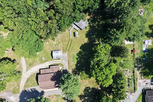
At the FAA's maximum altitude, one frame fits only the building at 182 US-209. The rest of the property doesn't exist in this photo.
Drone map
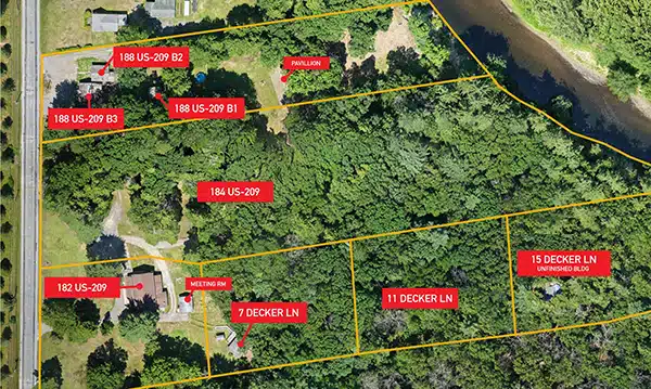
The entire 13-acre commercial property in one measurable image, with property lines exactly where they belong. This is what the buyer studies.
You can, but the result gets worse as the property gets bigger. Each photo is taken from a slightly different position, so the camera's angle to the ground shifts between frames. When those frames are blended, the geometry stops matching. On a small area the seams are tolerable. Across a large parcel the stitched image warps, distances stretch, and boundary lines drawn on top of it no longer land where the boundaries really are.
It's a perspective problem. A camera only sees objects as truly vertical when they sit directly beneath it. Trees, utility poles, and buildings near the edge of the frame are viewed at an angle, so they appear to lean outward, away from the center of the photo. Stitch several frames together and each one has objects leaning in a different direction, which is why stitched aerials often show trees that look tipped over and structures that seem to sag. An orthomosaic corrects this: because the map is assembled from hundreds of overlapping images, the software can use the straight-down view of every point on the property, so trees stand upright and features sit where they belong.
Stitched aerials
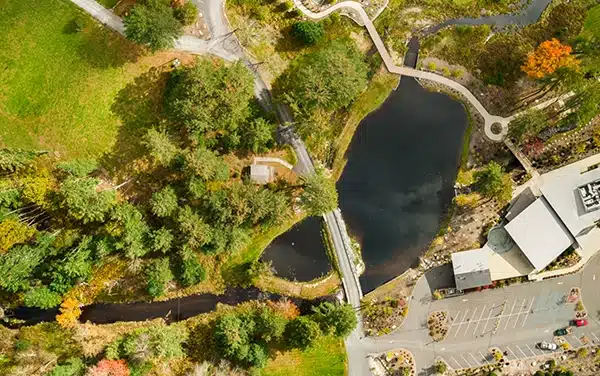
Several wide shots of this property blended together. Trees lean in different directions at every seam, because each frame viewed them from a different angle.
Drone map
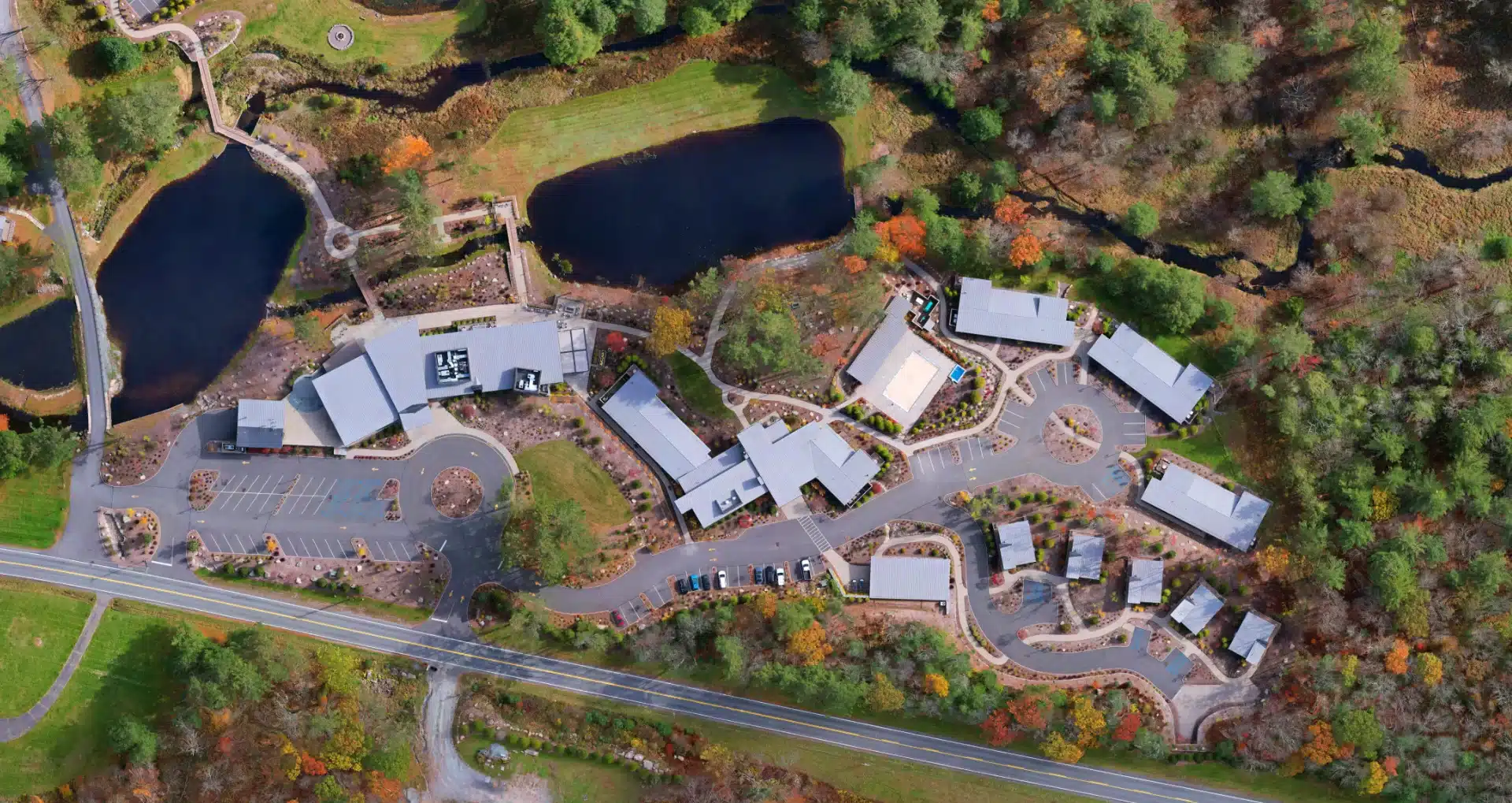
The same property, properly mapped. Built from hundreds of overlapping images, so the software uses the straight-down view of every point. Trees stand upright, and everything sits where it belongs.
Two reasons: the imagery is old and the resolution is low. Satellite views in mapping apps update on their own schedule, so the image behind those parcel lines may predate the cleared field, the new pond, or the neighbor's addition. And satellite imagery captures roughly a couple of feet of ground per pixel, which is why a zoomed-in screenshot dissolves into blur. A drone map is flown for your specific listing at a resolution of roughly an inch of ground per pixel, so buyers see the property as it exists today, sharp enough to zoom into any corner of it.
Because the work happens before the drone takes off and after it lands. A standard aerial shoot needs no prep: arrive, fly, shoot, edit. A drone map starts the day before, when we build the flight plan, plotting and programming the exact grid path so the automated mission covers every corner of the property with the right overlap. Miss a strip and there's a hole in the map, so the planning is not optional. The flight then captures hundreds of overlapping images. The commercial property map shown on this page took 277 images across three drone batteries to complete. Photogrammetry processing turns all of that into one geometrically accurate map: the software analyzes thousands of shared points across those images (a fence corner, a rock, a driveway edge that appears in ten or more frames), calculates the exact position and angle of the camera for every single shot, and then corrects each image so every point on the map is shown as if the camera had been directly above it. That's what removes the leaning trees, the warped seams, and the stretched distances that plague stitched aerials, and it's what makes the boundary lines trustworthy. All told, a map involves flight planning the day before, multiple batteries of automated flight, and an hour or more of processing and quality control, compared to a few minutes of flying for a standard aerial. You're not paying for a bigger photo. You're paying for a measurable document that a photo can't be.
Property lines and accuracy
Yes, and there are two ways to do it. The first is an approximate overlay: boundary lines drawn onto a regular angled aerial photo. The second is a true overlay on an orthomosaic map, where the parcel data aligns with the actual ground because the map is georeferenced and geometrically corrected. The overlay on an angled photo makes a dramatic hero image; the overlay on a map is the one buyers can trust for where the boundaries actually run. For land listings we recommend both: the aerial with approximate lines to stop the scroll, and the map to close the deal.
As an attention-getter, yes. As a boundary reference, no, and here's why. A perspective photo compresses distance: an acre near the camera fills half the frame while an acre at the back of the property fills a sliver. There is no accurate way to project flat parcel lines onto that geometry, so the lines are hand-fitted approximations that drift further from reality the deeper into the photo they go. Many agents request this style because they see other listings doing it, and it does work as a first image. Just don't let it be the image a buyer uses to judge what they're buying. Pair it with a true map and you get both the drama and the accuracy.
As accurate as the county's parcel data, placed correctly. The map itself is georeferenced, meaning every point corresponds to a real location on the ground, so the boundary overlay lands exactly where the county's GIS records say it should. The honest caveat is the records themselves: parcel lines in newer subdivisions are generally accurate within about five feet, while older rural parcels were sometimes mapped from fence lines or assumed boundaries and can be off by more. That's why every map we deliver is labeled as a marketing and planning tool, not a survey. Legal boundary determinations in New York require a licensed land surveyor.
Not to market it. A boundary survey is the legally definitive document, typically runs $300 to $1,500 for rural parcels, and matters for disputes, new construction, and some lending situations. A drone map does a different job at a similar or lower cost: it shows buyers the property. The two work together, not against each other. Many of our listings use the map to generate buyer interest and confidence, with the survey coming later in the transaction where it belongs. If a buyer needs stamped, survey-grade deliverables, we coordinate with a licensed New York land surveyor.
Yes, visually. Legal access is the first question serious land buyers ask, because a landlocked parcel can be worthless to them. On a drone map you can trace the driveway from the road, mark the deeded right-of-way where it crosses a neighboring parcel, and show exactly how much road frontage the property has. The map doesn't replace the deed or title work that proves legal access, but it lets a buyer see the answer instead of imagining it, and that alone removes one of the biggest hesitations in a land purchase.
Selling land faster
Yes, and this is the advantage most agents don't expect. Because the map is captured at roughly an inch of ground per pixel, you can crop into any part of it and the detail holds: the pond and its shoreline, the road frontage, the cleared meadow, the trail cutting through the woods. Each crop is accurate, sharp, and true to scale, because it comes from the corrected map rather than an angled photo. One mapping flight produces the full-property overview plus a gallery of zoomed highlight images for the listing, social media, and the property website, all from the same file.
Full drone map · Commercial property
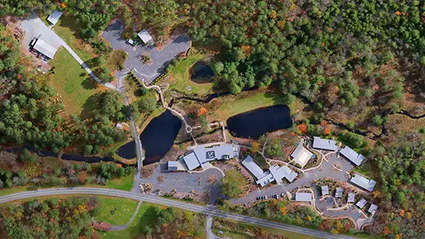
Detail crops from the same single map
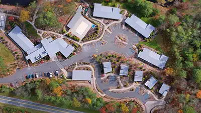
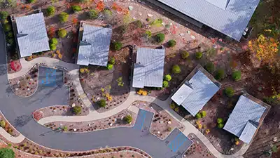
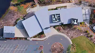
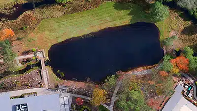
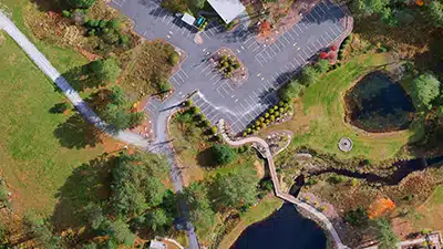
Every close-up above was cropped from the single drone map at the top, not photographed separately. Try zooming this far into a satellite view and the image dissolves. This is what an inch of ground per pixel means for a listing: one mapping flight delivers the full-property overview plus a gallery of sharp, true-to-scale highlight images.
The same ones, every time: How do I get in and out? Is any of it in a flood zone? How much is cleared versus wooded? How much road frontage is there? Where could a house go? Has it perc tested? A drone map answers the visual half of that list before the buyer ever calls: access, frontage, cleared acreage, terrain, and where features sit relative to the boundaries. The buyers who reach out after studying a map are further along, ask better questions, and waste fewer of your showings.
Because there's nothing conventional to photograph. A house sells with kitchen and bathroom photos; a wooded 15-acre parcel photographed from the ground looks like every other stand of trees in the county. Land buyers are buying a possibility, not a finished product, and a listing that offers only acreage, price, and a few ground-level photos leaves them to do all the imagining themselves. Most won't. Aerial imagery, a boundary map, and labeled features do that imagining for them, which is why visually documented land listings generate more inquiries from more serious buyers.
Anything over about 5 acres, which is where a single aerial shot stops being able to tell the story. Under that, a standard aerial photo package usually does the job and we'll tell you so. Vacant land benefits most of all, since the land itself is the product. A measurable map with labeled features gives buyers something to study before the showing and helps serious prospects self-qualify.
Mapping for parcels up to 20 acres runs $300, or $250 when bundled with an aerial photo package on the same visit. Parcels from 21 to 40 acres are $425, or $350 bundled. Larger properties are quoted individually. Every map includes a boundary overlay with acreage callouts, plus print-ready and web-ready files sized for MLS and marketing. Labeled feature callouts can be added for $75.
The work starts the day before the flight, when we plot and program the automated flight path so the mission covers every corner of the parcel. The flight itself takes 20 to 40 minutes for most residential listings while you or the seller go about your day. Processing happens after the flight, and finished files are typically delivered within a few business days, with rush delivery available for time-sensitive listings.
Let's begin
One flight gives you the map, the boundary overlay, and a gallery of sharp detail crops. Bundled mapping starts at $250 with any aerial photography package.
Mapping deliverables are marketing and mapping grade, intended for listing and planning purposes, and do not constitute a land survey as defined under New York State law. Every flight is operated by an FAA Part 107 licensed pilot.